

See Problems Before They Get Worse
Traditional roof inspections can require climbing ladders and time-consuming access. Horizon UAV uses professional drone technology to safely capture detailed Reports and measurements.
Our inspection can help identify
Roofing measurements
Missing or damaged shingles
Heat anomalies with thermal imaging
Roof penetrations measurements
Ponding water
Storm damage
Horizon UAV provides aerial imaging data collection and inspection documentation. Results should be reviewed by a qualified roofing or underwriting professional for evaluation.
Inspection Packages

PROFESSIONAL
ROOF INSPECTION
STARTING AT
$300
Our most comprehensive inspection package for detailed roof documentation.
-
Roof measurements
-
High-resolution aerial roof imagery
-
Close-up images of concerns
-
Detailed digital inspection report
-
DXF file available
BEST FOR
Homeowners - Property Managers-Insurance-Real Estate - Contractors.
Larger properties, multi-building sites, and custom need available. contact us for a custom quote
ENHANCE YOUR INSPECTIONS
Add-On Services
Thermal Imaging
Add thermal data to identify temperature differences that may warrant further evaluation.
STORM DAMAGE DOCUMENTATION
Detailed aerial documentation after severe weather events for insurance and property records.
BEFORE & AFTER DOCUMENTATION
Perfect for roofing projects, repairs, and maintenance tracking,
Prioroty Turnaround
Get your data faster with priority processing.
Simple Process. Powerful Results
Consult & Plan
We learn about your project goals and create a custom flight and data plan.
How It Works
We Capture
We Process
Get your Insights
Make Better Decision
Our pilots capture high resolution areial data on you schedule
Data is processed, organized, and analyzed for accuracy and insight.
Access your data, reports, models, online anytime.
Use real data to keep your projects on track and your team aligned.
See whats's possible
Example Project Deliverables


Hi-Resolution Aerial Imagery
Detailed area Documentation

Thermal Imaging
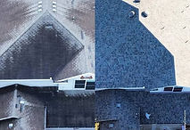
Before & After

