

Complete Project Intelligence From Above
Our Construction Intelligence Package provides a complete view of your project from start to finish. We capture, process, and deliver accurate aerial data that helps you monitor progress, identify issues early, and keep every stakeholder informed.
Track progress with high-resolution aerial imagery.
Accurate measurements and volumetrics
Compare against plans and schedules
3D models and digital twins
Identify issues before they become they becom costly problems
Share insight with your entire team
Perfect for general contractors, owners, developers and investors
Our Services

PROFESSIONAL
INTELLIGENCE PACKAGE
STARTING AT
$300 per visit
Comprehensive data and reporting for project visibility
-
BiWeekly aerial missions
-
High-resolution photos & video
-
Site map
-
3D model
BEST FOR
Small Projects - Subcontractors Owners - Early-Stage Builds - General contractors - Developers - Project managers - Commercial Builders
Custom packages available for projects of any size. Contact us for a tallored solution
ENHANCE YOUR INSIGHTS
Add-On Services
360° Site Walk
360° video walk of the site
CAD & BIM Intergration
Integrated drone data with CAD/BIM workflows.
Time-Lapes Video
Professional times-lapes video of your project.
Prioroty Turnaround
Get your data faster with priority processing.
Volumetric Measurements
Receive detailed volume calculations and visual reports to support inventory management and material tracking.
Simple Process. Powerful Results
Consult & Plan
We learn about your project goals and create a custom flight and data plan.
How It Works
We Capture
We Capture
Get your Insights
Make Better Decisions
Our pilots capture high resolution areial data on you schedule
Our pilots capture high resolution areial data on you schedule
Access your data, reports, models, online anytime.
Use real data to keep your projects on track and your team aligned.
See whats's possible
Example Project Deliverables

Hi-Resolution Aerial Imagery
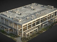
3D model & Point Clouds

Progress Dashboard
